Navigating the modern world has become easier thanks to digital mapping technologies. While Google Maps is one of the most widely used navigation applications worldwide, there are also alternatives that may better serve different needs. In this article, we will detail the features offered by Google Maps, explain how to use it more efficiently, and explore the best alternatives that might be more suitable for specific situations.
Real-Time Traffic and Road Condition Tracking with Google Maps
How does Google Maps show real-time traffic conditions?
Google Maps analyzes traffic flow using advanced data collection methods. GPS signals, speed data obtained from mobile devices, and traffic camera data allow the app to continuously update road conditions. The color codes on the map help users easily identify which roads are congested or clear.
- Red: Heavy traffic and delays
- Yellow: Moderate congestion
- Green: Smooth traffic flow
Additionally, users can report accidents, roadworks, and other obstacles on Google Maps. These updates help other drivers adjust their routes accordingly.
Google Maps also analyzes traffic conditions for different modes of transportation. For example, public transport users receive real-time updates on delays for bus and train routes. This feature is particularly beneficial for time management in major cities.
Offline Maps: Navigate Without an Internet Connection
How can Google Maps be used offline?
Even when there is no internet connection, Google Maps allows users to navigate by downloading offline maps. This feature enables users to save a specific area’s map in advance and receive directions without an internet connection.
Advantages of Offline Maps:
Reliable navigation in areas without an internet connection: Ideal for rural areas or international travel.
Mobile data savings: Since it does not require constant internet access, it minimizes mobile data usage.
Faster map loading: Offline maps load faster than online maps as they are stored directly on the device.
How to Download Offline Maps:
- Open the Google Maps app.
- Enter the location in the search bar.
- Use the “Download” or “Offline Map” option to save the map to your device.
This feature is especially useful for travelers and users with limited mobile data plans.
Lesser-Known Features of Google Maps for Smarter Navigation
What are some lesser-known features of Google Maps?
Google Maps offers much more than basic navigation services. Here are some useful yet often overlooked features:
- Adding multiple stops: Plan a route with multiple destinations efficiently.
- Speed limit alerts: Helps drivers stay within legal speed limits.
- Real-time parking information: Displays available parking spaces at your destination.
- Indoor maps: Provides navigation inside large shopping malls, airports, and hospitals.
- Google Assistant integration: Enables hands-free navigation using voice commands.
These features enhance both driving and walking experiences, making Google Maps more convenient.
Best Google Maps Alternatives: Which One is Better?
What are the best navigation apps other than Google Maps?
While Google Maps is the most widely used mapping application, some users may benefit from other options. Here are some of the best alternatives and their advantages:
- Waze: Offers real-time traffic updates and community-driven alerts, ideal for urban driving.
- HERE WeGo: Great for offline navigation, making it perfect for travelers in foreign countries.
- Mapbox: Provides customizable mapping tools for businesses and developers.
- OpenStreetMap (OSM): An open-source platform that is continuously updated by the community.
- Bing Maps: Integrates seamlessly with Microsoft products, making it a preferred choice for businesses.
Choosing the right alternative depends on your specific needs and preferences.
Planning the Most Efficient Routes for Driving, Walking, and Public Transport
How can Google Maps be used efficiently for different transportation modes?
Google Maps offers optimized routes for various transportation options. Here’s how to make the most of each mode:
- Driving: Suggests the fastest route while allowing users to exclude toll roads or highways.
- Walking: Displays the shortest and safest paths while providing elevation details.
- Public Transport: Shows real-time schedules and potential delays for buses, metros, and trains.
By using these options, you can plan your journey more effectively and save time.
What are the usage rates of Google Maps for Navigation worldwide?
According to the data on https://apnews.com/, the usage rates of Google Maps for Navigation worldwide are as follows:
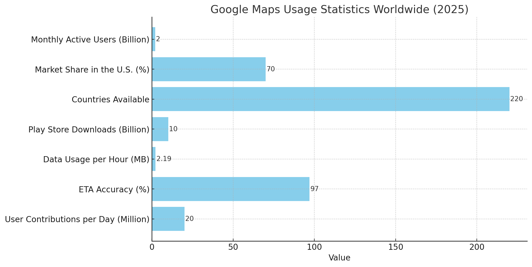
Here is a bar chart visualizing the global usage statistics of Google Maps in 2025.
10 Effective Ways to Save Time with Navigation Apps
How can navigation apps help save time?
- Regularly check traffic congestion analysis.
- Evaluate alternative routes to avoid delays.
- Download offline maps to reduce internet dependency.
- Save frequently visited locations for quick access.
- Follow real-time traffic reports to adjust your route.
- Use voice commands to minimize distractions.
- Monitor public transport schedules for the best options.
- Research parking availability in advance.
- Plan routes efficiently to reduce fuel consumption.
- Switch between different map layers for better visibility.
By applying these strategies, you can optimize your navigation experience.
Google Maps remains one of the most popular navigation applications thanks to its advanced features. However, alternatives like Waze, HERE WeGo, Mapbox, and OpenStreetMap may be more advantageous for specific use cases.
Determining the best mapping app for your needs requires assessing your travel habits and testing different options. As technology evolves, features like AI-powered route optimization and augmented reality navigation will continue to enhance the way we navigate.

